


vtt_circuit_noir_2_42_km

yt34
User
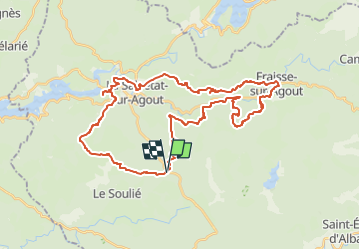

Length
43 km

Max alt
1017 m

Uphill gradient
1171 m
Km-Effort
58 km

Min alt
670 m

Downhill gradient
1167 m
Boucle
Yes
Creation date :
2024-08-18 07:35:15.71
Updated on :
2024-08-18 07:48:44.971
4h01
Difficulty : Very difficult

FREE GPS app for hiking
 SityTrail
IGN / Geographical institutes
SityTrail Plus
The world is yours!
About
Trail Mountain bike of 43 km to be discovered at Occitania, Hérault, La Salvetat-sur-Agout. This trail is proposed by yt34.
Description
Circuit VTTFC Noir 2 départ du col de la Baraque
Positioning
Country:
France
Region :
Occitania
Department/Province :
Hérault
Municipality :
La Salvetat-sur-Agout
Location:
Unknown
Start:(Dec)
Start:(UTM)
477718 ; 4823214 (31T) N.
Comments